By Meghan Christie, Intern
Preserving and protecting the watershed is surprisingly multifaceted.
Part science: we assess and monitor the geology, hydrology, biology, and botany of each project.
Part management: we align agencies, consultants, contractors, and volunteers to get the job done.
Part funding: we find the grants, cost-sharing, and donations needed to finance each effort.
Part education: we tell locals, visitors, and water-users about our stressed and fragile ecosystem.
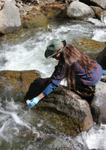
Photo by Stefan McLeod
A thorough and comprehensive understanding of conditions across the entire watershed is vital to science, management, funding and education.
Thanks to a remarkably dedicated group of volunteers, our Adopt-A-Stream monitoring program has been collecting water quality data from the same 25 sites within the watershed for the past 21 years. Tracking the chemical and physical characteristics of our local streams, creeks, and rivers helps us identify where ecological functions are working well, and where they need help.
A variety of measurements are taken at each monitoring site, to gather a more complete picture of the ecosystem and to monitor changes or patterns across short and long periods of time. Some parameters can be measured instantly, but others need analysis.
Because we give the volunteers the right equipment and supplies, they can get instant measurements for dissolved oxygen, conductivity, pH, and water temperature:
- Dissolved oxygen is vital to all life within the river, and low levels, caused by high water temperatures or excess bacterial activity, can be fatal to fish.
- Conductivity is measured to identify potential sources of dissolved solids or salts. High conductivity indicates impaired water quality. Common causes of high conductivity in our watershed include road salt and sand.
- The pH of the water designates whether the water is acidic or basic. Water outside a specific pH range will not easily support aquatic life.
- The hot summer sun warms the water in all water bodies in the Middle Truckee River Watershed. The average monthly water temperature of the Truckee River in the winter is below 5⁰C, but climbs to 15⁰C in June, and to almost 20⁰C in July and August. This temperature increase affects all life in and around the river. Our restoration projects improve groundwater and surface water connection, supplying cooler water for fish and macroinvertebrates.
Other parameters, such as nutrient concentrations and turbidity, require water samples to be taken and then analyzed in a laboratory:
- Phosphorus concentrations are measured to better track nutrient loading. Large quantities of phosphorus can enter the river system via fertilizer and household runoff, and can cause algal blooms, which create anoxic (without oxygen) conditions.
- A separate water sample is taken for turbidity. Turbidity is a measurement of the amount of particles suspended in the water and helps identify areas of increased erosion. Both the U.S. Environmental Protection Agency and the State of California list the Truckee River as Impaired (polluted) for sediment. Suspended sediment particles diffuse sunlight and absorb heat, which can increase water temperature and decrease light availability. This can affect fish and invertebrate populations.
To take a deeper dive into the data, please visit our website to read our Annual Monitoring Data Reports.
What questions do you have about the Truckee River watershed?
We’d love to hear them!
To keep up to date on our projects, sign up for our newsletter and follow us on social media (Facebook & Instagram).
P.S. Many thanks to the donors and volunteers of the Truckee River Watershed Council for supporting Adopt-A-Stream! Would you like to join, too?