by Phoenix Anthony, Office Manager
We have learned more about what happened in Coldstream Canyon.
Walking west and upstream in Coldstream Canyon, we found turbidity (cloudy and brown water) up to about 7,000 feet. All along the way there was erosion from former landslides, bank failures, and beaver dam failures.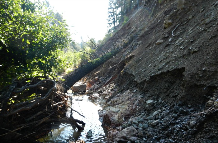
It appears the storm was very intense in the upper watershed, toward the Sierra Crest. Sediment was from a combination of natural sources such as exposed soils, and a few human-caused sources like old logging roads. From this information we distinguish that while there may have been some human-caused sedimentation sources, most of it was coming from the combination of weather patterns and naturally exposed soils. When situations such as this are occurring, the best defense is restoring areas of our watershed so that they are better equipped to handle them.
A prime example is our restoration project in Coldstream Canyon. If this project had not taken place in 2012 and 2013, the eroding banks along the creek would have led to even more sediment flowing into the Truckee River. Instead, not only did it withstand the increase in water flows and sediment, the project was able to act as a filter.
If you have enjoyed learning about our watershed and our project in Coldstream Canyon, engage with us further during a River Talk. Our River Talks are an opportunity for you to ask us questions, give us important feedback, and gain information about the TRWC’s future projects to protect our watershed against drought, large storms, and other damage.
Thank you to Becky Bucar (Town of Truckee), Beth Christman (TRWC), Richard Eiri (Placer County), Brian Hastings and Dave Shaw (Balance Hydrologics) for contributing to this post
Photo: Middle fork of Cold Creek, note the bank erosion that has lead to the fallen tree and turbid water. Credit: Brian Hastings (Balance Hydrologics)